Sunday, May 19, 2019

SUMMARY FOR THIS PERIOD ON THE AT. April 9 through May 11, 2019.

Dates:  Tue., April 9 through Sat., May 11, 2019.
Days on trail:  33. Total days on trail (including 2016):  89.
Beginning point:  Mile 808.1. 37.7236N79.2509W. Near Buena Vista, VA.
Ending point:  Mile 1,1195.5. 501 Shelter. On PA Route 501.
Miles hiked on this trip:  387.4
Miles to go:  996.5
Average miles per day:  11.7 miles hiked per day. I took four zero days.
Average miles per week (4.7 weeks):  82.4 miles per week.
Based on 82.4 miles per week time to finish trail:  12 weeks.
Average hiking speed (not calculated. scanned past days):  2.3 mph. Range hiking speed:  2.1 to 2.6.

It has been a rewarding adventure back on the AT. I have hiked all day in the rain a couple times. I didn’t encounter any snow or extreme cold weather this time. Probably because I started later in the year, and was not as high of elevations as the Smokies. I strained my left knee when I first started because I started by climbing two high mountains with steep inclines and descents. I took two days off, got a knee strap, and trekking poles. Both knees are good now with no problems. Steep descents are still hard on them, but the poles help a lot with the descents. I have enjoyed hiking hiking in the cooler weather, and do not look forward to returning to the heat and humidity.

It was definitely harder this time. I hadn’t trained as much, which was a problem. I didn’t think it would be. It also wasn’t as rewarding/fun as last time. I am hoping when I go out again I will get more enjoyment out of the experience.


Thanks for your interest and support.

Sun., May 12, 2019. Headed home. 1,1195.5 / 996.5 to go.

It is forecasted to rain hard today and tomorrow. Boarderline, caretaker for the 501 shelter, offered me a ride to Harrisburg, PA. So, I decided it was better to head home now rather than hike for 3 more days. That meant I didn’t break 1,200 miles, or 400 miles this trip. I felt bad about that, but am okay with it. I am glad to get home sooner, which I believe will get more done at home, and get me back on the trailer sooner.

Boarderline recommended that I start my hike in Hannover, NH. Hike south to his location. Then return to Hannover and start hiking the White Mountains. I will research it and consider it.

He gave me a ride to Harrisburg airport. I rented a car. Went and did laundry. I stayed at the Radison Inn. It is a very nice room. I got a good price through priceline.com. Priceline messed up my stay date, but the receptionist figured it out and corrected it. Thank goodness.

I traveled home the next day, May 13th, on Delta through Detroit. I got on both of the first flights and was in SLC about 10:30 am. It was tight. I got the last, or second to the last seat out of Detroit. I thought I would be in Detroit all day.


No pictures. We have all seen plenty of airports. :-).

Sat., May 11, 2019. Day 33/89. 501 Shelter. 40.5143N76.3460W. 17.9 miles. 8 hrs, 15 mins. 2.2 mph. 1,195.5 / 996.5 to go. (NOTE: .4 miles added because of extra distance caused by Beaver dam alternative route.

A very good day. I was surprised how good I felt at the end of the day. My feet didn’t feel as bad as they have before. There is a caretaker for the shelter. His name is Borderline. I asked his advice about a ride to the airport. By the time we discussed it raining the next two days and transportation he offered to drive me to Harrisburg Airport tomorrow. So, that is what I am going to do. Head home tomorrow. I called Linda and told her. She sounded excited that I was going home three days earlier. I am excited as well.

The trail had an alternate section because of a beaver dam that had been built and submerged the trail. I choose to take the alternate course. It was a good decision for me. It added .4 miles, but was a smooth and easy climb road. I made much better time than if I would have gone over the beaver dams. Nicholas reported to me that he went over the dams. He had to wade up to his knees with his flip flops and it was slow. That made me feel good about my decision.

The 501 shelter is a unique shelter because it is completely enclosed and has a caretaker. I think there is only one more on the trail that is completely enclosed. It has 12 bunk beds. There ended up being 6 people in the shelter. 

It is located close to a highway. It was possible to order pizza. We did that. Of course it was good. It is very easy to get spoiled on the trail. I actually had enough left over of my dinner the next day at the hotel.

Here are the names of the hikers. They are all younger, college age. They are also dedicated hikers. They got up early the next day and started out in the rain. It was, and did rain steady, and moderate all day. I would have been soaked by the next shelter which was 15 miles away. 

Nicholas - I have already talked about him.

Cheerleader - She is from the Netherlands. She has a spark and very friendly to all. She talked a lot. I have noticed that when women are at the shelter there is more conversation. Mostly that is good. She has done a lot of traveling through the world.

Chocolate-lady. Wears Chocos to hike in. That is where she gets her name. She isn’t college age. She is my age. I have been at several shelters with her. She is a little annoying some times. She has an opinion about everything and shares it. 

Nitro - Seems to be the leader of a group of three that are hiking together. Quiet compared to the women, but shared in the conversation.

Fire _______ - I can’t remember the second part of his name. He is very quiet. He is a little older that Nitro and Cheerleader. He hikes with them.

Pictures:

1. Another historical sign of the area.
2. 2 pictures of signs about beaver dam and alternate route. Added .4 miles to length of trail.
3. Trail through a field, looking back. These two trees were all by themselves in the middle of the field. Made a good picture.
4. Snake in the middle of the trail. Fortunately, not poisons.
5. View from trail into valley.
6. Spring is here and the new growth is beautiful.


Fri., May 10, 2019. Day 32/88. Rauschenberg Gap Shelter. 40.4987N76.6000W. 18.0 miles. 8 hrs, 00 mins. 2.3 mph. 1,178.0 / 1014.0 to go.

It was a long 18 miles, but worth getting to the next shelter. It was suppose to rain all day with possible thunderstorms. It didn’t happen till late afternoon. I was blessed. I got to the shelter, got in under the shelter and in 5 minutes it started to rain hard. Was I so lucky, or blessed. I will say I blessed. Thank you.

Today I had to climb a 1,000 foot high mountain. The trail had a moderate grade. I was able to climb most of it without having to stop to get my breath. Much better than my first week on the trail. The trail was rocky and muddy. That made the going harder. I am liking my boots as they are handling the rough terrain better than the lighter weight shoes I see people wearing. Mine, also stay drier. 

Over all it was a good day. The concern on my mind is that I have to do the same day for the next 5 days. Along with that it is going to rain hard on Sunday. I am going to look at another possible pickup point to go into Allentown.

I am thinking that I need to tell more about the different hikers. They are interesting. Here are the people that were at the shelter.

Lief and Debbie. I am very impressed with them. Debbie said a year ago they were just sitting watching TV, eating snacks, getting heavier, and unhealthier. They decided to do something about it. So, it was hike the AT.

They started hiking the end of March. They are slow. They say they are going about 1 1/2 mph. They have had major problems. Problems that would have sent me packing home. First, he is carrying a CPAP machine. He carries two batteries for it. He about four to six days before they have to go somewhere to recharge. Next, after being out for a short time he got Shingles. They had to go get that addressed and healed. He said he would have quit, but she wouldn’t let him. Then, he had a fainting episode because his blood pressure dropped. When Debbie checked the drug out the web there was warnings about not doing physical exercise with that prescription. They had told the doctor and pharmacist about hiking the AT, but neither questioned using that drug. The good thing was his blood pressure has dropped because of hiking the trail, exercise. They have him on a new drug. He also told us that in three weeks of hiking he has lost 30 pounds. He thought some of that was water retention. He is still a large man, but had a lot of energy. As I said, I was very impressed. It made me realize my sore feet are a poor excuse for questioning hiking.

Many people I have camped with have said that I am doing a lot with doing 15 plus miles a day. I feel that I am a moderate hiker. Many of the people I see are hiking at, or faster, the same rate.

Another person at the shelter was Chills. I met him about a week ago. He was at the shelter the night before. He is about 
40. He didn’t think he could make it the 18 miles to this shelter. He did it. Unfortunately, he and Nicholas, were a little behind me and got caught in the rain when it started. He chose to keep hiking and not put on rain gear. He was soaking wet. His pack was dry though. In the rain you have to keep your pack dry. You do not have to keep yourself dry. Chills chose to put up his tent rather than sleep in the shelter. There was plenty of room, but he chose to camp. It had stopped raining when he set up his tent. He did start later. He came down to the shelter to cook his dinner with us. He hasn’t been hiking to long. He is doing a flip flop, which means you start at Harpers Ferry and hike to the end. Then come back and hike the southern half. That way you avoid the bubble of hikers. I think he is still getting his hiking legs and wondering if he really wants to do this.

Nicholas. He is younger than me. I would way about 25-30. He grew up in France. Then migrated to Canada. He started in the Yukon for several years. He now lives in Quebec. He is hiking a section. Many people hike sections. Over several years, maybe many, they hike the entire section. He will hike for another week, then his girlfriend will pick him up. He says his girlfriend worries about him. He carries a satellite reporting device. I have seen several of them. They send a position report every mile or so. You can also record a couple messages which you can tell the satellite app to send. For example, I am at camp for the nigh and all is okay. I have camped with him at a couple shelters. He says he is having a tough time doing the longer miles. Again, getting his hiking legs.

When we both left this shelter he said he wasn’t going to make it to the shelter I was going to. As I hiked I felt he might. He 
did. It was good to see him. I gave him a bad time and told him I thought he would make it. At the next shelter you can get pizza.
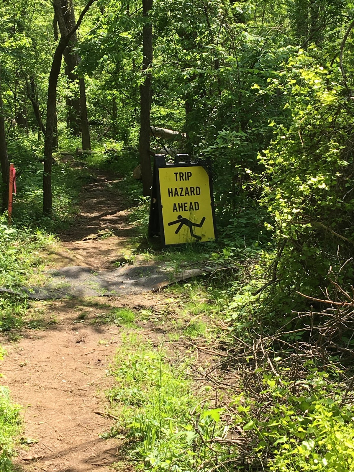
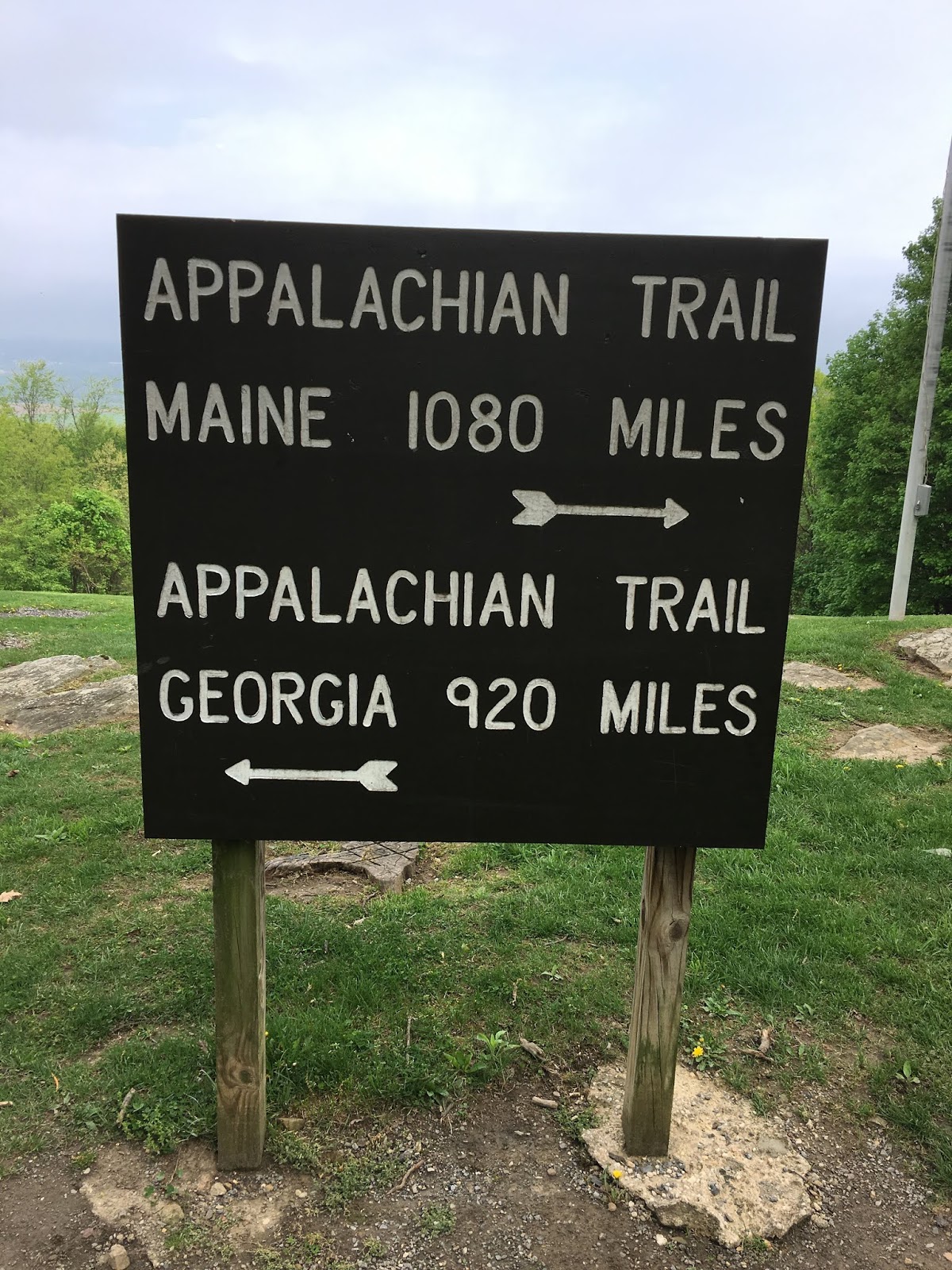
Pictures:

1. A creek I passed. There use to be mining if this area. I wonder if this is from that. I wonder if my filter would remove the color? Doubt it.
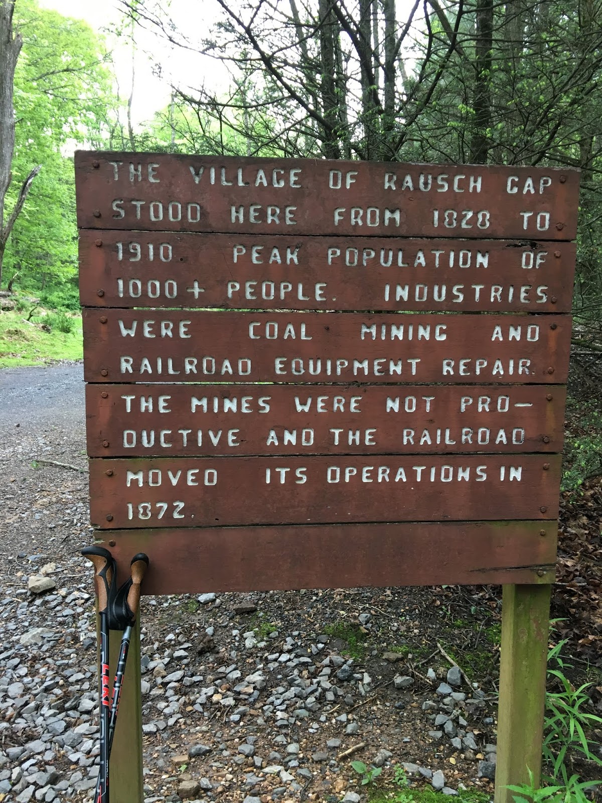
2. A sign talking about the past. I marvel when I see signs like this. This is in the wilderness. I wonder what towns and roads use to use this area. 
3. The shelter I stayed out. 


Thur., May 9, 2019. Day 31/87. Peter’s Mountain Shelter. 40.4257N76.8793W. 11.2 miles. 5 hrs, 00 mins. 2.2 mph. 1,160.0 / 1032.0 to go.

I woke up a little after 5 am and got up. I felt good and felt like I needed to make up for my bad day yesterday. 

I refigured my stopping points. I determined that I needed to do a short day, 11.2 miles, today to get in sync with the shelters. Once in sync the shelters are all 16 to 18 miles apart. Perfect. With 17 miles on the 15th I will end up hitting PA Route 248 that goes into Allentown, PA. There are 3 Delta flights a day from there. Again Perfect. Uber charges about $30 for the ride. I will check on a regular shuttle driver, but know I can use Uber or Lyft if needed.

I showered, put on some neosporen and bandaids and was ready to go. My scrapes were not deep. I had no problems hiking today from them.

The weather report said 60% at 2 pm. I wanted to be at the shelter by 1 pm. I made it. It never poured rain, but drizzled all afternoon. I missed it. It is very cold at the shelter. I am going to sleep good, once I go to bed.

This shelter had a water source, but not close, and steep to get to. It was .2 miles away. A sign posted said it had 300 steps to get to. I believe it. It was down a steep hill with rock steps going down to it. Which met also going up them. See picture of spring and note steps next to it. The spring came right out of the mountain, was visible for less that 150 feet and then disappeared. I wonder how they ever found it.

Pictures:

1. Two pictures of my combat injuries with the sidewalk.
2. The sidewalk that I tripped on the day before. It was 1 1/2” raised.
3. Picture of the trail. Tough trail to hike. The rocks are always tough and slower.
4. Water source. It is always to key to how far I hike and where I will camp. Most shelters have a good water source like this spring. 
5. Steps to water source. The camera doesn’t show how steep it is.


Wed., May 8, 2019. Day 30/86. Red Carpet Inn, Duncannon, PA. 40.4503N76.9765W. 17.5 miles. 7 hrs, 40 mins. 2.3 mph. 1,148.8 / 1043.2 to go.

Today I finished crossing the Cumberland Valley. If you look at the picture looking back over the valley you can see some mountains in the distance. I came out of those mountains yesterday. I crossed the valley yesterday afternoon and this morning. It is about 15 miles across. Sometimes when I look back I marvel how fast I cover a distance. I’m not very fast, just constant.

When I got to Duncannon I was trying to follow the map in the AWOL guide book that was on my phone. I shouldn’t have been doing that. I was trying to find an ice cream store that was on the map. The side walk had a section that had raised 1 1/2”. I tripped on it. I scraped my knee and had a cut above my left eye. A couple who lived there came out of their home and helped me. They were true trail angels. By the time all was done they had cleaned and bandaged up my cuts and given me a ride to the motel. I had tried to call the motel, but their phone was continuously busy. They had available rooms. When I told them about heir phone, sure enough it was down. He had to reset it.

I showered and cleaned up the cuts that are only scrapes, so I should be okay to leave in the morning.

Pictures:

1. American flag hanging on the AT bridge that crosses US Route 11 at the edge of Carlisle, PA.
2. More of Cumberland Valley, PA.
3. Cumberland Valley coming to an end. Ahead, that you can see, are the mountains I will climb. Not to high.
4. Pretty wildflowers. Picture doesn’t do them justice.
5. Looking back across Cumberland Valley. Read first paragraph about mountains in distance. I cam out of those yesterday morning.
6. Sign about entering Cumberland Valley, I of course am leaving it.
7. Me at Hawk Rock with Duncannon Town in back ground. That is the Susquehanna River.
8. Steps coming down from Hawk Rock to Duncannon City. Very steep and tricky. About 1/2 mile of them.


Tue., May 7, 2019. Day 29/85. Super 8 Motel, Carlisle, PA. 40.2330N77.1089W. 16.6 miles. 6 hrs, 30 mins. 2.6 mph. 1,131.3 / 1060.7 to go.

Last night I saw that the trail went right by some hotels at 17 miles. I figured I could stay there and have someone deliver my pack so I could slack pack. So, I did it. It was probably the easiest hike for a full day that I have done on the entire trail. The first 1/3 had a couple mountains that were no greater than a 500 foot climb. Then the rest was gradual farm land in the Cumberland Valley. I read that it is a 13 mile section that is the longest, lowest, and flattest section on the entire trail. I agree. They were almost level. With no backpack I made great time. 

During the last climb in the mountain section I came upon a lady who had twisted her ankle and leg. I carried her pack to the top of the hill. My Boy Scout good deed for the day. :-). The rest was a gradual downhill she said. She had come from that way. I offered to carry it more but she said no. That slowed me down, otherwise I would have made it to the the Motel a half an hour earlier. It was a very easy day. I hardly sweated. 

I met Shade Hunter. He served in Iraq for several years. Someone had told me about him at a shelter. He is about my age, maybe a little younger. The other night when it was raining he came to the shelter, saw it was full and then walked off. None of us at the shelter realized he had left. When I saw him today I told him we all felt sorry that he left. We would have made room for him. He said he didn’t feel anyone said that , or felt that. He just observed it. He ended up camping a couple miles down the trail in the rain. The next morning I saw where he had written his name in the trail. We talked about it. He seems like a great guy. He related how in Boiling Springs a couple had picked him up and had him stay with them. Nice people, true trail angels.

Pictures:

1. Cumberland Valley ahead. Level for 13 miles. Sweet.
2. Boiling Springs. Plaque telling about the town of Boiling Springs. The trail goes through the town.
3. Two pictures showing a blast iron furnace in Boiling Springs.
4. Steps over a fence with a white blaze painted on a pole on the other side to mark the trail.
5. A cemetery from the past.
6. What?? A warning about a trip hazard on the trail. Most of the trail is a trip hazard, I do trip. My guess is that OSHA required the contractor to put it up where they are working. I laughed. Haven’t seen a warning before, and don’t expect to see one again. :-).


Mon., May 6, 2019. Day 28/84. Holly Inn in Mount Holly Springs, PA. 40.0915N77.1681W. 3.3 miles. 1 hrs, 20 mins. 2.5 mph. 1,114.7 / 1077.3 to go.

My plan worked. This last week I figured my mileage so I would be at a shelter only about 4 miles from the town I would stay in. That way I would have more time to get all of my off the trail day items done. Here Is a list in case you are interest. Laundry, blog (takes a lot of time finishing and uploading), phone calls, planning future route for food mailings, buying supplies, equipment repair and purchase, drying equipment from rain (big job), repacking, catching up on emails and texts, and a little R&R. Oh, also eating some real food and sleeping in a real bed. 

Often I would like to stop, but don’t do it because of the logistics of a town not being convenient.

The sun was out and I got everything dried in a quick time. My tent was completely wet. It took the most effort.

My backpack is getting a hole in it where the internal frame hits the bottom. When I am home I am going to have to somehow sew over a heavy material patch. I am concerned that the frame will poke out and then the pack will not stay upright. Could be a major problem.

Pictures:

1. Only one poor picture of the inside of a shelter. Note there are only 3 walls. I am taking the picture in the morning as people are getting ready to go. I am taking it from above in my bed.

I should have taken one of the Holly Inn in Mount Holly Springs, PA. It is a quaint town.


Sun., May 5, 2019. Day 27/83. James Fry Shelter. 40.0630N77.2063W. 17.1 miles. 6 hrs, 40 mins. 2.6 mph. 1,111.4 / 1,080.6 to go.

A very significant day:

I passed the official half way point. See the picture. This is a very important accomplishment to me. It almost seems impossible to me that I have hiked 1,111.4, half the distance.

Second, I passed 300 miles since I started this year.

NOTE, NOTE:  Note that the miles to hike is less than the miles hiked. Am I excited. YES.😀😊🙃😊☺️😁ðŸĪĐðŸĪŠðŸ’Đ

It rained all day. I was soaking wet when I got to the shelter. I fortunately was able to change to dry clothes and be in a shelter. I got an upper bed bunk and didn’t have to sleep on the floor. I feel wonderful as it still pours hard outside the shelter.

Walking in the rain is terrible. You get wet. Even with a poncho you get wet. I wonder if I get wetter with a poncho, or with out one. I think I sweat more than being in the rain. At least the sweat stays warmer. My very expensive water proof boots felt damp, but I think it was my sweat, and not water getting in. The rain is suppose to stop tonight, at about 8 pm. So far, at 5:45 pm it doesn’t look like it is going to every stop. It has been a consistently moderate rain.

About noon time the trail went through Pine Grove Furnace State Park. There was a small resupplies store and cafe. There were several hikers there. They raved about the hamburger. They had a hikers burger. So I had it. It was good. It was worth the stop.

I got ahead of the group from the last shelter. Five I passed while hiking. A couple I saw at the store and left before they left. I was the fourth person at the shelter and got one of the four beds. Five others came. They slept on the floor that was meant for four people. It was raining so no one was going to tell someone else they had to set up a tent.

It was a good group in the shelter. Two older, including me, three mid age that were together, and four younger. We played the heads up game. I was the expert how to play it because I have played it with my grandchildren. I didn’t do very good on my turn. As usual we went to slept by 8 pm.

It was a wonderful morning to wake to no rain, and none in the forecast.


Pictures:


  1. Halfway point marker for the entire Appalachian Trail. Ypee!!!! Note mileage on sign. Exact.
  2. Me - Wet and hiking. At the shelter when I arrived.


Friday, May 17, 2019

Sat., May 4, 2019. Day 26/82. Birch Run Shelter. 39.9848N77.4194W. 15.7 miles. 6 hrs, 35 mins. 2.4 mph. 1,094.3 / 1,097.7 to go.

I was able to balance out the mileage. Tomorrow I will do 17.1 That is better than the 19+ that I was going to do. The day after I will be hiking only 3.3 miles from the shelter to the pickup point to go to the Mount Holly Inn. They have a food box for me, plus a night stay. It is forecasted 100% to rain tomorrow. It is 6 pm and it has already started to rain. I will probably have to pack my bag in the rain tomorrow morning. I guess that is how you have memories. Serves my right for hiking on Sunday.

I was planning on staying in a shelter tonight. I arrived, took of my backpack and talked with people there. Three men hiked in after me. Said, any room left. One of the woman there said, yes 3 places. He immediately said we will take them. In a blink of the eye I am camping outside in the rain. If they show up where I am tomorrow that isn’t going to happen. As soon as I get there I am going to grab a spot. I plan to be there early. I want to start hiking tomorrow at day break, 6:00 am.

I do not think the hikers that came in after me were trying to sneak into my spot, but it happened. It did end up raining all night long and the next morning. I did end up packing my wet tent in my back pack. The first time I took it out was when I was at the hotel. It was dripping when I took it out. Fortunately, it was sunny and I was able to dry out everything.

Pictures:
  1. Me. I was taking one of my 3 hour breaks. Every 3 hours I stop, take off my pack, and drink some of my extra water that I carry in my pack. It refreshes me. Very helpful.
  2. Three pictures of the trail. The third shows tree routes in the trail.


Fri., May 3, 2019. Day 25/81. Stealth Camping on trail. 39.8385N77.5050W. 17.7 miles. 8 hrs, 20 mins. 2.1 mph. 1,078.6 / 1,1113.4 to go.

A good day of hiking. First I passed the Mason Dixon line. In this area this is a big event, line. I do not know why. If you ever wonder if people still honor the South, the answer is a very strong yes. I will let you figure out the significance to the line. Second that same line is the Maryland and Pennsylvania border. In three days I walked through the state of Maryland, any way that part that the AT traverses. 

I also had my first trail magic. See the picture below. It was wonderful. There are many people that leave treats for hikers that come along. I had a candy bar and chips. Very good. THANK YOU TRAIL ANGELS.

There was to be a thunderstorm at 1 to 2 pm. My goal was to make it to the Tumble Run Shelter by 2 pm. I made it at 1:25 pm. People told me warning was moved back till 5 pm. I decided to hike till 4:30 and then set up camp. I had to carry my water. I carried an extra 1 gallon and 1 quart. That is about an extra 8 pounds. Right from the shelter there was a steep climb. I did okay. The big win is tomorrow. I am cutting down longer legs as I move to my hotel on the 6th.

As far as the thunderstorms it started at 7:15 pm. I had some light showers, but that was all. The interesting thing is that I can hear the thunderstorm to the south of me. It is suppose to pass through and be dry in the morning. I hope so.

There were two different groups that were hiking to the next shelter that passed me. I could have done that, and got there at about 6:30 pm. Tonight will tell if I made the right decision. It is fun and scary to hear the thunder so close. I might get lucky and it will pass to the south, but I do not expect that.

Good hike today, even though there were some tough areas. Good weather. Sunny.
I sucked in 3 bugs while breathing hard while climbing a steep hill. Spit them out, I hope. Sucking in bugs isn’t fun. I have to start breathing harder with my mouth closed. Not sure I can do that.

I got some more mosquito bites last night. So, I am itching again. The first thing I did when I arrived at camp was to spray on some Deet. Hope it helps.

I am liking my new hat. I have had several complements about it. One guy said that I knew I was always on the right trail because it has a white blaze in it. I took it off, turned it around, and said I hope I never get that loss of the trail that I have to look at my hat.

Well the thunderstorm really came. It started at 7:45 pm. I expect it to last about 45 minutes. I was wrong. Ended at 10:15 pm. My estimate wasn’t any good. My tent is doing good. I am dry and cozy typing on my iPad and reading the scriptures. There could be multiple storms, which could last most of the night. I am in a lower area and so far haven’t had any strong winds. There are trees all around me. I will report tomorrow how long the storm lasted, and if I had any problems. The last thunderstorm I was in with this tent I was on top of a mountain, in the open, and next to some radar and radio equipment. I was truly worried that time. Tonight no large concerns as long as my tent stays dry. So far so good. Good Night.ðŸ˜ī.

PS. Next morning. The storm did as it was suppose to. It passed through during the night and all was dry in the morning. All is good.

Pictures:

1. Sign in a park in the city of Pen Mar, Maryland. Located very near the Mason Dixon Line.
2. Mason Dixon marker.
3. beautiful stream. Looked like a good fly fishing stream.
4. Trail Magic left where the trail crossed a highway. Thank you trail angles.