Tuesday, April 30, 2019

Tue., April 30, 2019. Day 22/78. Harpers Ferry, West Virginia. 39.3217N77.7440W. 8.4 miles. 3 hrs, 20 mins. 2.5 mph. 1,024.6 / 1,167.4 to go.

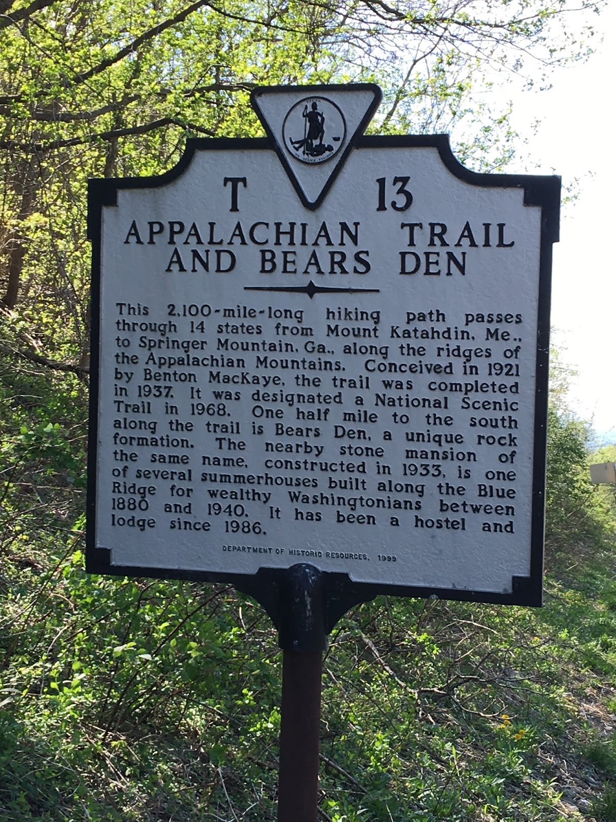
I was anxious to get to Harpers Ferry as this is designated the half way point. I got there early so I could look around town and check in with the ATC - Appalachian Trail Conservancy.

At the headquarters I got my picture taken and entered into their record book. I was the 102 section hiker to register this year. 

The town is small, but full of history. They have many historical buildings and the park service has tours. The John Brown raid occurred here. Before the civil war he tried to over take the national armory to get arms to start a slave up rising. His attempt failed and he was hung. It was a major event before the civil war.

The Shenandoah and Potomac Rivers join together here. Three states also come together, separated by the rivers. Virginia where I finished hiking in, West Virginia, where I am now, and Maryland, where I will start hiking in tomorrow.

I got my clothes washed and I showered and ready for another day, tomorrow on the trail.

I enjoyed my visit.

Pictures:

1 & 2. Bridge crossing Shenandoah river from Virginia to West Virginia.
3.  In front of AT Conservancy headquarters. A big event for all hikers to get their picture taken and put in the record book.
4 - 5.  John Browns last stand.
6 - 7.  Jefferson,s Rock.
8.  Picture of Harpers Ferry.
9.  Niagara monument.
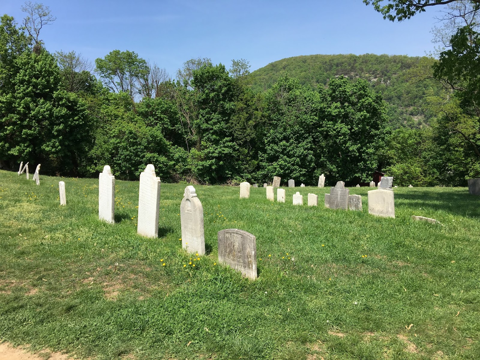
10 - 11. Harpers Ferry cemetery.

12.  Cannon & armory building in back ground. 


Mon., April 29, 2019. Day 21/77. David Lesser Memorial Shelter. 39.2271N77.7786W. 10.6 miles. 5 hrs, 15 mins. 2.0 mph. 1,016.2 / 1,175.8 to go.

Another good day.

The Coxs hiked with me for the first part of the day. It was very enjoyable to have them hike with me. They have been great hosts over the weekend. It was hard to leave the comforts of their home.

I passed the Virginia / West Virginia States line today. Leaving Virginia is a major accomplishment because it has more AT in it than any other state.

I also hiked pass 200 miles since I started hiking this year. I feel like I am on my way now to hike the entire trail. It did take me three weeks to do it though. Pretty slow. I am not concerned about it because I had four zero days in those three weeks. As I am getting back in the rhythm My weekly miles will increase.

I got in the shelter early. The water was 1/4 mile away down a steep trail. It was a good spring. The water tasted very good and refreshing. Though it was a tough, no trail miles.

I met Faircaster at the shelter. He is a through hiker. He started Feb 28. He plans to finish on his birthday of July 28. He says he will have to slow down, but for now he wants to get ahead. He is doing about 25 miles a day.

I met:

RD - Residential Dad. He is younger and people do not like calling him dad.
Farmer. Retired from special forces and bought a farm. 
Vagabond Jack. Met him before, had forgot the Vagabond part of his name.
A couple with a dog Denali. Great dog. Very fit.

Pictures:

1.  Hiking with Coxs.
2.  AT surveyor marker.
3.  Blane and me ready to conquer the wilderness.
4.  State line.
5. Very rocky and rough trail.
6 & 7. Flowers.

8 - 10. David Lesser Shelter.


Sun., April 28, 2019. Day 20/76. Coxs. 0 miles. 1,005.6 / 1,186.4 to go.

I went to church with the Coxs. They have a large ward. The had over 200 at sacrament meeting. They had meetings before and after the block. I had a lot of time to work on my blog. 

After church they had two couples come over for dinner. Blane made chicken schnitzel. Judy made a broccoli salad and other dishes. We ate and visited for several hours. It was very enjoyable.


I hurried and got mostly packed after dinner.


Sat., April 27, 2019. Day 19/75. Snickers Gap, VA 7. Coxs picked me up. 39.1159N77.8524W. 14.4 miles. 7 hrs, 25 mins. 1.9 mph. 1,005.6 / 1,186.4 to go. Slack Packed.

A tough section of trail. After about 1 mile into the section there was a sign saying the section ahead was called the roller coaster. The next 12 miles plus were steep up and down, thus the name. I was slow. With a light pack I thought I would be faster, but it didn’t happen. It was a long tough day.

I passed the 1,000 mile point on the AT. I was excited. I couldn’t find any marker. There was a beautiful Dod Wood tree at the spot, so I took a picture of it. See below.

After my hike we drover over to the little city of Corner Bridge to buy some ice cream. Their bishop recommended it. It was soft ice cream and was good.

It has been very enjoyable to be with the Coxs. They are spoiling me. Sure beats food and accommodations on the trail.

Pictures:  

1 & 2. Coxs and me.
3 - 5. Trail pictures. Note how rocky. Very tough section.
6. Dogwood tree at the 1,000 mile mark of the AT.
7. Butterfly. I see other kinds but they fly to much for me to get a picture.
8. View to the west, where Coxs live.
9. Highway sign about the AT.


Fri., April 26, 2019. Day 18/74. Coxs went to Washington D.C. 0 miles. 991.2 / 1,200.8 to go.

The Coxs had a retirement ceremony in Washington DC. I went in with them. While they attended that I went to the African American museum. It is very well done. There are three floors under ground that talks about the history of the blacks in the US. I got through about 2/3, but went through quickly. I would like to go back.

Before I went to the museum I had a couple street vendors hot dogs. They were good. I loaded them up with toppings. 

After visiting Washington we went to a Noodles house restaurant that the Coxs like. It was good food. I had sushi and a Benton plate. 

Good day, even though it was a zero day.

Pictures:


All from Washington DC.


Thur., April 25, 2019. Day 17/73. Ashby Gap - US Route 50 & 17. Coxs picked me up. 39.0167N77.9648W. 14.8 miles. 6 hrs, 55 mins. 2.1 mph. 991.2 / 1,200.8 to go.

I found my iPad screen cracked when I took it out of my pack. It is one line. Hopefully, it will stay that way and not shatter. It has a protective screen over it so it should keep working.

Feet very sore on the bottom. The bottom of the feet haven’t bothered me before.  Hope it is a passing pain.

The Coxs picked me up. It was great to see them. I got to the parking lot before them and was able to wash in a creek and change my shirt. At the end of the day I am always wet from sweating after hiking for the day.

Pictures:
  1. Mosby’s Confederacy sign.
2.  Stone wall in the middle of no where. Why is my question? What history does it hide? Did someone live here at one time? There are no other clues.

3-7.  Flowers and path.


Wed., April 24, 2019. Day 16/72. Jim and Molly Denton Shelter. 38.8900N78.0829W. 18.6 miles. 8 hrs, 5 mins. 2.3 mph. 976.7 / 1,215.3 to go.

I left Shenandoah National Park today. 

This was the best shelter I have stayed at, or seen. It had a large deck with a large lounge bench. It had a separate eating bourse. It had a solar shower. Plus a separate fire pit.

I arrived before anyone else. I took a shower. It was cold, no solar warm water. It had a hose hanging down with a garden spray on the end. I didn’t get a picture of the inside. I rinsed my hair and used a wet cloth to was the rest of my body, and then quickly rinse off. It felt great. I also rinsed all of my clothes. I had clean underwear, socks, and clothes to put on while the others dried. It was another wonderful, interesting experiences on the AT.

I fell today. My trekking pole got stuck in some mud. As I pulled it out my left foot stuck which caused me to fall. I fell on my pole and creased it. Still works. Not sure if it will slide together. I am using my poles less than half the time. They are helpful for steep uphill and downhill. Helps me climb faster by helping me stay more erect. Other than that I am carrying them because they slow me down. I am still sold on them for helping my knee and stability.

Big day of 18.6 miles. Tough on feet, but rest of body doing good. My feet were very sore. They should not be that sore. The boots I bought were advertised as the perfect hiking boot. I have decided I do not have the perfect hiking feet.

As I was hiking I noticed that my pack was rubbing on my hips. Something new. I pulled up my pants and buckled my pack belt under my waist belt. It worked. No more problems with my back pack rubbing on my hips. It seems like every day a new pain or problem has to be addressed. Hopefully soon I will get them all figured out and will just have to hike. Get more into the swing of just hiking and thinking. No interruptions.

Pictures:


  1. Tree in blossom. Sorry, I do not know the name.
  2. Denton Shelter and eating pavilion.
  3. Shower. So refreshing. Plus clothes drying.


Sunday, April 28, 2019

Tue., April 23, 2019. Day 15/71. Gravel Springs Shelter. 38.7640N78.2337W. 13.1 miles. 6 hrs, 10 mins. 2.1 mph. 958.1 / 1,233.9 to go.

This was the last shelter in SNP. Tomorrow I leave SNP. 

We had Breakfast at Elkwallow Wayside in SNP. Along with a breakfast sandwich I had a scoop of the SNP famous black berry ice cream. It was very good.

I split up with No Service and Wow. They went further. I had no reason to go as far as I was meeting up with the Coxs the next day. 

When I got to the shelter there were 4 ladies there. They were taking a lunch break and had their shoes off. I thought they were staying because it was 2 pm. I was impressed with them. They had large packs and good equipment. They appeared to know what they were doing and enjoying it. I have been impressed with the number of women on the trail. All without men. Very impressive to me.

This shelter had the best looking stream coming right of the mountain. It probably didn’t need filtering, but of course I filtered. See the picture below of where it is coming out and the amount. Amazing what Mother Nature does.

Captain America was also at the shelter for the night. He is about my age, maybe a little younger. He went to bed at about 7:30. I went to bed at about 8:00 pm. He snored so loud that I had to wake him. He offered me some ear plugs, which I accepted. After that he didn’t snore as much. I think he just needed to be rolled over.

At about 5 pm a large and younger group of thru hikers started to arrive in camp. It was a pre bubble group. College age. They are doing about 25 miles a day. Today they did 29. Impressive. Most slept in tents. Only two slept in the shelter. I think we, Captain America and I drove them away. There were also about five other small groups there. It reminded me of my last hike with the bubble. To many people. The younger group didn’t stay up to late. 
They were serious about covering the miles. They got up at sun light and were on their way before me. I wish I had the strength and energy they have. They were a good group and respectful. The shelter area was over crowded though.

Rip was an individual hiker and not part of the group. About 40 years old. He was south bound. He was trim and looked like he was ready to hike. He is section hiking.

Pictures:
1. Still waiting for the leaves.
2. Water at the shelter. Note it comes right of the mountain in the picture, the green area. Also note how much the flow is.


Mon., April 22, 2019. Day 14/70. Pass Mountain Shelter. 38.6767N78.3189W. 18.8 miles. 8 hrs, 40 mins. 2.2 mph. 945.0 / 1,247 to go.

Wow:  Wow was over a trauma / emergency room in Tasmania. He is 64. He is now retired. He did part of the PCT, Pacific Coast Trail, with his wife. He and No Service played off each other and were funny. I enjoyed camping with them.

No Service:  No Service has taught middle school. He is 69, about to turn 70. He developed and ran an outdoor course for twenty years. It sounded like he was very successful with the program. A very nice guy.

We stopped and had breakfast at the Skylane Restaurant. They had a buffet. It was very good. I am sure part of the reason it was so good is because of the food I eat on the trail.😊. It did make hike the next hour hard with being so full.

Speaking of hiking, it is getting better. I am still struggling going uphill, but not as bad as the first week. My feet are still suffer from the boots, but they are also getting tougher. Hopefully within the next week they will not have pain spots, or ache as much. I have to get tough!

Pictures:


  1. Great view to the west.
  2. Looking north at Skyline Drive, the road in SNP. Note no leaves yet in SNP. Just starting to come on.
  3. AT marker in SNP. These looked like they were 50+ years old. Only in SNP do they use these kind of markers. The silver band strips have direction and distance markings. Also note trekking poles and knee band. They solved my left knee problem.